Menu Close

How do we plug the geospatial skills gap in Scotland?

How do we plug the geospatial skills gap in Scotland?

March 2024
Location Data Scotland hosted a fruitful conversation at the AGI Scotland conference on 27th Feb 2024.

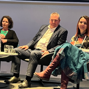
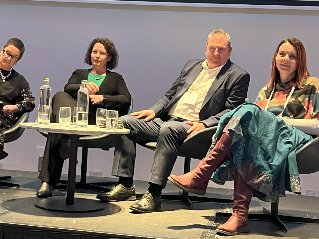
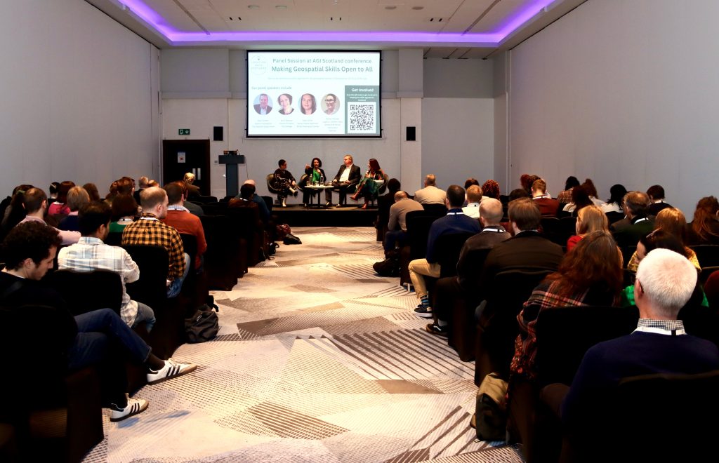
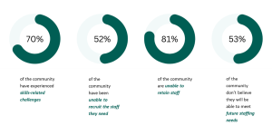
A diverse audience of industry, public sector, academia and students met to discuss strategies to tackle the skills gaps across the sector in Scotland at the recent AGI Conference. While Scotland has the highest rate of geospatial jobs in the UK, the demand is primarily concentrated in major cities like Edinburgh and Glasgow. Skills gaps are clear. Individuals keeping up with rapid advancements in technology areas like remote sensing, Geographic Information Systems (GIS), and data management can be challenging and extracting meaningful insights from geospatial data requires strong analytical and data visualisation skills.

Skills Panel at the AGI Conference
From left to right, Ashley Stewart, Lead on Location Data Scotland, Jenni Doonan, Fife College, Alan Corbett, Scottish Government and Nikki Smith, British Geological Survey.

There are also gaps across different industries like environmental management, urban planning, and transportation, which have specific applications for geospatial technologies. Understanding these nuances and creating a range of blended skills to the chosen field and individual industry sectors is crucial.

As a nation, there is limited geospatial training/skills pathways available, currently study is only available at MSc level. And whilst most people ‘fall into geospatial’ as a career rather than choosing it as a path the lack of pathways causes recruitment challenges for the sector. The problem lies at the lower end of the education ladder – schools, colleges and community projects involving young people (Scouts, Youth Clubs etc) and to attract young people into the industry and choose geospatial as a career path, they need to have the knowledge much earlier in the educational journey. Most school aged children have played Pokemon Go but what they don’t realise is that the technology powering that game is geospatial and it opens up a full spectrum of exciting skilled jobs and opportunities. A huge knowledge gap also lies with parents who don’t see geospatial as a career path for their children. Education needs to be given to parents, with clear examples of the power of this technology across different sectors such as financial services, agriculture, space and tourism.

Geomatics Manager at Shell, Rob Dunfey said:

“I am very supportive of initiatives to build geospatial skills. Obviously, there is value for employers such as Shell in being able to recruit geospatial professionals, but more importantly for broader society and the economy. I truly believe that geospatial skills are going to underpin our energy transition to net zero.”

Skills Panel Session at AGI Conference hosted by Location Data Scotland
Picture courtesy of Cameron Easton on behalf of AGI Scotland

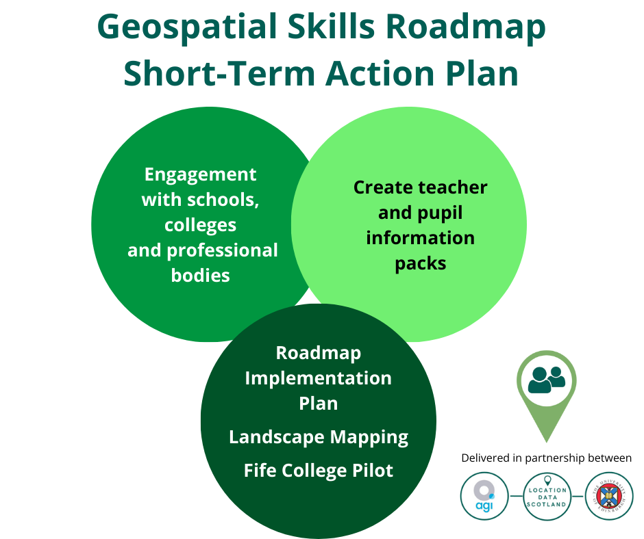
Location Data Scotland working in partnership with University of Edinburgh and AGI Scotland are calling for industry to help close the skills gaps. More information is needed from industry to define the essential future skills for the geospatial industry at all levels within their organisations, not just individuals at MSc level.

We need your help. Please get involved in the programme so we can help influence future generations to consider geospatial as a career path. If you would like to be part of this movement, register your details here and we’ll be in touch with next steps.

Register Now

LDS to host skills panel at the AGI conference

LDS to host skills panel at the AGI conference

February 2024

Developing the skills agenda for the geospatial sector in Scotland is critical to ensuring a pipeline of skilled talent is available to expand the economy and grow the sector. Scotland is currently limited to courses at MSc level; thus, impacting the breadth and diversity of individuals training and coming into the sector.

By bringing together leaders from industry, and academia LDS, in partnership with University of Edinburgh and AGI Scotland, has been working over the last 2 years to identify the skills gaps in geospatial across Scotland and has created a unified skills roadmap for the future. Our ambition is to create more jobs using geospatial skills and make Scottish talent more marketable to industry, attracting more companies to set up in Scotland as there will be a cluster of skilled talent, and a dedicated pipeline of highly skilled personnel to support emerging industry requirements. The work on developing the skills roadmap has resulted in a first-of-its-kind pilot programme being initiated with Fife College to develop and test a dedicated geospatial skills course as an introduction into the Geospatial industry.

We are delighted to be hosting a panel at the AGI Scotland conference on 27th February 2024 in Glasgow, bringing together key individuals from across the sector to build on the work already done and explore where we go from here.

Alan Corbett, Head of Geospatial at The Scottish Government

Alan heads up the Scottish Government’s Geographic Information Science and Analysis Team (GI-SAT) within the Digital Directorate. Alan has worked in the Scottish Government’s Geographic Information Service (then SEGIS) since 1998 when the geographic information was first introduced within Government. He has been instrumental in promoting the use of GIS within Government and the Scottish Public sector and is delighted to see how GIS mapping and analysis has developed into an integral part of the decision making process for policy directorates and senior Ministers within the Scottish Government.

Alan’s primary responsibility is giving advice to both internal and external stakeholder on how GI data, systems and analytical processes support strategic decision making across all Scottish Government Directorates and its partner organisations with projects such as the National Resilience and recently the Government Covid Response. He is also responsible for substantive projects or initiatives within the Scottish Government such as the collaboration and procurement of geospatial data for the Scottish Public Sector. Leading on the Public Sector Geospatial Agreement (PSGA) for Scotland, Alan’s role is to ensure it delivers strategic direction, robust timely data and value for money to support all Scottish Public Sector organisations in the delivery of their statutory requirements.

Jenni Doonan, Head of Projects, Faculty of Engineering & Technology, Fife College

Jenni had a 15 year career working in engineering in the European Space Industry before moving into education. She has spent time working at the University of Edinburgh on the Data Education for Schools project as part of the Edinburgh and South East Scotland City Deal before moving to Fife College as Head of Projects in the Faculty of Engineering & Technology. She is responsible for developing innovation projects which give the college the capability and capacity to provide education in new and emerging skills areas.

Nikki Smith, Senior Digital Specialist, British Geological Survey

Nikki is a Senior Digital Specialist within the International division of BGS and has a focus on the design, development and implementation of custom spatial data capture and delivery systems, as well as the design and implementation of digital workflows. Nikki also works extensively with international geological surveys as they aim to increase the use and delivery of their geospatial data, and her work has taken her from Europe to Africa to Central and SE Asia. In addition, Nikki is the Vice-Chair for the Association for Geographic Information – Scotland committee.

Ashley Stewart, Senior Consultant for Optimat and Lead for Location Data Scotland

Ashley co-ordinates and manages Location Data Scotland, on behalf of Scottish Government, to transform services and create new products using geospatial technologies and/or location data in Scotland.

She specialises in data, digital and emerging technologies. Ashley is experienced in techno-market/demand analysis, technology roadmap development, strategy and commercialisation support to private and public sector organisations. Ashely has a BA (hons) Marketing, an MSc IT with Web Development and a PhD in Technology Enhanced Learning and Communities of Practice.

Book your place for the AGI conference

A focus on skills for Scotland’s expanding geospatial sector

A focus on skills for Scotland’s expanding geospatial sector

February 2024

A recent article in Scottish Business News highlighted the focus on skills for the expanding geospatial sector in Scotland, a direct result of the work carried out during the Location Data Scotland pilot programme.

📌 LDS in partnership with The University of Edinburgh and Association for Geographic Information (AGI) Scotland have created a unified skills roadmap for the geospatial sector.

📣 A first-of-its-kind pilot programme has been initiated with Fife College to develop and test a dedicated geospatial skills course as an introduction into the Geospatial industry.

Rebecca Reid, Skills and Capabilities Policy Lead at Geospatial Commission said:

At the Geospatial Commission, our strategy is to ensure the UK stays ahead of the curve in revolutionising location data and technologies. Location Data Scotland supported by University of Edinburgh and AGI Scotland has been instrumental in driving the skills agenda forward, encouraging academia to actively consider this as part of their course curriculum.

This is a great step forward for the geospatial sector in Scotland.

Showcasing the support provided by Location Data Scotland

Showcasing the support provided by Location Data Scotland

January 2024
Working with organisations to help them develop innovative solutions, access data and make connections are just some of the key benefits that have been generated as a result of support provided by the team at Location Data Scotland.


Four companies have made huge strides over the last 3 years. In the following case studies, we hear from each of the businesses and understand how this support has really helped them scale up and grow.

Douglas McNeil, Managing Director, Eolas InsightEolas Insight offer automated mapping solutions for the environmental and ecological sectors.

Doug McNeil, Managing Director of Eolas Insight shared his thoughts on the support they received from Location Data Scotland, “LDS has helped raise our brand profile as a start-up company through several platforms and events to talk about our services and promote the company. The best example of this was being an exhibitor on the Scottish Innovation Village at GEO business 2023 (organised by Location Data Scotland) in London. We made a lot of connections at the show, including RICS who are now supporting one of our projects. We also met several investors at the event and at the time were going through seed investment. The investor who is leading our current seed investment round was a connection we made at the event. This investment will help us take the company to the next level and begin our scale up journey – all thanks to Location Data Scotland.

Watch Eolas Insight video case study

Chris Newlands, Founder and CEO, Space AyeSpace Aye is an innovative technology company who merge Internet of Things (IoT) data with real-time satellite imagery to provide in-depth information surrounding satellite imagery, creating a global view of the world.

Founder and CEO of Space Aye, Chris Newlands shared his thoughts on how Location Data Scotland has helped them in their scale up phase, “Being on the Location Data Scotland Scottish Innovation village at GEO business 2023 was a great platform for Space Aye to raise our profile and discover a number of exciting opportunities including how our technology will assist autonomous vehicles as they move to a fully autonomous stage (level 5). We also had interest from a transportation company at the show interested in the benefits of real-time satellite navigation. Location Data Scotland has also helped escalate our conversations with the policing organisations across the UK and emergency services in Scotland who see this technology as a game-changer in terms of accuracy and security. This has led to discussions with other emergency services organisations around how our technology can provide real-time satellite information to minimise wildfires.

Watch Space Aye video case study

Michael Groves, Founder and CEO, TopolyticsTopolytics is a data aggregation and analytics company who are making the world’s waste visible, verifiable, and valuable.

Founder and CEO Mike Groves commented on how Location Data Scotland has helped their business, “Location is a crucial part of our proposition and being linked to LDS is critical to our business as it helps us understand what other people are doing within the network. LDS has provided networking and showcase opportunities for Topolytics including being part of the Scottish Innovation Village at GEO Business 2023 which provided us with a platform to engage with potential partners and customers. It also gave me some ideas on how we could build our own contextual data to understand where the sites are that are managing and processing things around waste material and how could technologies be applied in that process.

Watch Topolytics video case study

Arun Gopinath, CEO and Co-founder, VahanomyVahanomy, a location data company, has two innovative products that use AI to escalate the rollout of the electric vehicle charging infrastructure and decarbonised transport.

CEO and Co-founder Arun Gopinath shared his thoughts on how Location Data Scotland has helped Vahanomy, “We were introduced to the Improvement Service who support local councils and government across Scotland who provided access to data from Scottish local authorities to evaluate the sources of data. We also received introductions to Scottish Government, Ordnance Survey, Registers of Scotland, and the Geospatial Commission who were carrying out a survey into the use of data for electric vehicle charging infrastructure, which we were able to contribute to. These introductions were instrumental to helping us grow our business – we got to the right person quickly and effectively, something that would have been difficult to do on our own. LDS also helped us raise our brand profile by inviting us to speak at events and showcasing our solutions through their newsletters, website, and social media. All thse elements have been very helpful for our business.

Watch Vahanomy video case study

We have a number of case studies on our website highlighting where location data is being used to drive innovation.

Agri Tech Event

Agri Tech Event

October 2023
Coming this November

Join us on Monday 9th November at the Royal Highland Centre in Edinburgh for an exciting event which seeks to foster collaboration between Space, Agriculture, Forestry and Financial Services, showcasing how space data can support the needs of land based and financial services sectors.

Delivered in partnership with Scottish Enterprise ESA Space Solutions and C2 Network, we will explore the advancements in satellite technology driving the adoption of technology in agriculture.

Click below to find out more and book your place.

How do we address the skills shortfall?

How do we address the skills shortfall?

September 2023
The development of geospatial skills in Scotland is falling behind other countries.

A recent article in Geoconnexion co-authored by Ashley Stewart, Senior Consultant at Optimat and Lead on Location Data Scotland, Bruce Gittings, Senior Lecturer in Geographical Information at University of Edinburgh and Tom Janes from the Improvement Service examines the key findings from the work undertaken to develop the skills roadmap for Scotland.

The article identifies where the skill gaps lie and why it is essential to make changes now, to help the geospatial sector flourish.

You can read the full article here.

GeoBiz 2023 update

Location Data Scotland at GeoBiz2023

GeoBiz 2023 update

June 2023
From Innovations in Space to Environmental Impact, it was all going on at GeoBiz 2023!

Hosting the Scottish Innovation Village at Geo Business in London for two days we caught up with the 7 organisations who exhibited alongside Location Data Scotland to find out more about their technology and what their highlights were from being at the show.

Eolas Insight provide automated mapping solutions predominantly for the environmental sector. Their highlight of being at Geo Business was the ability to be part of the Scottish Innovation Village and talking to the other companies on the stand to discuss potential collaborative opportunities.

Space to Consumer capture real time satellite imagery of people, animals and life form. They met with some key brands at the show who were very interested in their technology including Tom Tom and Amey. Space to Consumer also formed a strong partnership with one of the companies on the Alley and were discussing a potential collaboration.

Trade in Space’s technology uses satellite data analysis and blockchain technologies to make agricultural commodities traceable and sustainable. They attended the show to introduce their two highly innovative solutions; Digitrak and Sustainimaps.

NERC Field Spectroscopy Facility are a lending library for researchers sharing specialist equipment. They came to Geo Business to identify and build partnerships with key players to help improve their commercial activity.

Topolytics are a data analytics company providing solutions to make the waste supply chain more visible. Their CEO and founder Mike Groves highlighted how important it is for companies such as Topolytics to be part of the wider Scottish ecosystem and collaborate with other companies to share best practice and form partnerships.

Geovation are an accelerator programme supporting geospatial businesses in Scotland. Their partner manager Jess Sibley highlighted why it is essential for Geovation Scotland to be part of the Location Data Scotland community.

Craft Prospect is a NewSpace company providing AI-enabled space technologies, quantum encryption services and mission systems consultancy.

Alan Corbett, Head of Geospatial at the Scottish Government said,

Location data plays such an integral role in stimulating and promoting innovation within the Geospatial Sector. Location Data Scotland is working with some highly innovative organisations across Scotland and the UK, promoting the fantastic things currently being undertaken with location data. Having our own dedicated Scottish Innovation Village at Geo Business highlights the importance of the innovation and entrepreneurship being generated in Scotland, and the pivotal role Scotland plays in the wider UK Geospatial ecosystem.

LDS to host a ‘Village of Innovation’ at Geo Business 2023

Expo 2020 Dubai 3rd February 2022
Photograph courtesy of Spelfie; Space to Consumer

LDS to host a ‘Village of Innovation’ at Geo Business 2023

May 2023

Location Data Scotland is hosting the Scottish Innovation Village for the first time at Geo Business 2023. Taking place in ExCeL, London on the 17th and 18th of May, Geo Business is one of the UK’s largest geospatial and location intelligence exhibitions showcasing the newest tech, tools, and solutions for geospatial. The show is co-located with Digital Construction Week highlighting the latest trends in digital construction in which geospatial plays a pivotal role.

The Scottish Innovation Village is situated at the heart of Geo Business and will showcase some of Scotland’s leading-edge technology organisations working in geospatial including:

Read the full story in Scottish Business News

Private and Public sector unite to unlock the Power of Location Data

Private and Public sector unite to unlock the Power of Location Data

April 2023
March Webinar Update

In our March webinar we heard from Simon Roberts, Data and Engagement Manager at the Improvement Service and Arun Gopinath, CEO of Vahanomy talking about their partnership formulated through an introduction by Location Data Scotland and where they saw ‘The Power of Location Data’.

The Improvement Service is owned by the 32 Scottish Local Authorities, COSLA and SOLACE and one of their focuses is to create a more consistent and comprehensive evidence base for decision making by enabling better access and usability of local government data.

The Spatial Hub is the Improvement Service’s flexible and scalable, online platform that provides standardised access to Scottish local authority data. A key objective of the platform is to stimulate innovation and improve productivity for organisations across Scotland. The platform addresses the challenges that organisations face around accessing public sector data.

Local government data custodians are invited to provide data sets to the Spatial Hub, which are then transformed and published into more harmonised national datasets which can be accessed by any authorised organisation or user. Organisations such as EDINA at the University of Edinburgh are sharing the Spatial Hub data via their DigiMap service with most academic and research institutions across the UK.

The Improvement Service has been working with Vahanomy Limited, an Edinburgh based start-up developing innovative artificial intelligence data driven B2B solutions to enable the accelerated rollout of electric vehicles (EV) charging infrastructure globally. Through an exploratory licence for the Spatial Hub, Vahanomy can access local authority data sets that have been critical to the development and testing of their innovative technology.

Arun said:

When we started out, we encountered lots of challenges accessing data around where electric charging points could be located including:

  • sourcing accurate, current, standardised, easy to handle and affordable data,
  • developing predictive models to use this data to pinpoint the electric charging points.

Through Location Data Scotland (LDS) we have been introduced to a number of key data suppliers like the Improvement Service, which has been important for us to access quality data. We also were able to connect with Ordnance Survey, Scottish Government, Registers of Scotland and the Geospatial Commission. As a start-up with limited resources, it is difficult to connect with the right contacts. Ashley at Location Data Scotland has a fantastic network of connections and she easily started opening doors for us to the right people across the location data domain.

The Spatial Hub has provided Vahanomy with access to 40 spatial datasets through their exploratory licence.

Simon Roberts commented:

The Spatial Hub could become a sort of ‘one-stop shop’ for Scotland’s local government and public sector spatial data if this was deemed necessary and we are working with other parts of Government such as health organisations and SEPA to evolve the data sets we currently support. Companies who are interested in accessing or supplying this data should get in touch with us via our website.

A list of available data sets from across the UK can be found here.

Available Data Sources

Public/Private Sector Disconnect

There is a massive question around how we bring together the public and private sectors to unlock the data being generated across the public sector? Lots of best practice is already being created in the private sector as organisations find solutions to similar data challenges. To address the issue and find solutions, first we need to understand the challenges. And bring together suppliers to share their insights and knowledge to try and solve the challenges.

Project Manager for Location Data Scotland Ashley Stewart said:

Our role in Location Data Scotland is to bring together an inclusive community of entrepreneurs, industry, third sector, academia, and public sector to collaborate, drive innovation, create opportunities and efficiencies and unlock the value in location data across multiple industries and sectors. We have a key role to play in helping address the public/private sector disconnect and our strong community of members could be the conduit to unearthing both public and private sector challenges and finding solutions.

The Power of Location Data

The Power of Location Data

March 2023
Location Data is integral to the technological advancements of many industries.

Location technologies (both indoor and out) are spurring the evolution of rapid digital transformation and innovative new solutions across almost every part of daily life.

These systems rely on three main location data sources:

  1. Geographic information systems (GIS) which use a variety of types of location-based data to build 3D visualizations and maps
  2. Indoor positioning systems (IPS) that find and track people or things indoors using a range of different technologies
  3. Internet of Things (IoT) devices (like beacons, sensors, etc.), which provide data to inform GIS and IPS systems

Location Data Scotland’s webinar, The Power of Location Data on Tuesday 30th March, will provide a case study of Scottish technology company Vahanomy Ltd discussing the importance of accessing rich data for their technology and the partnership they have formed with the Improvement Service to access datasets via their Spatial Hub.

Register below for this event to uncover a rich library of data sources and form partnerships with key data providers generating data and others looking to source data.

With the global geospatial market forecasted to be $681 billion in 2025 according to Geobuiz, we have seen data become exponentially richer over the last 5-10 years. The market is estimated to grow at a much faster rate post-2025, making it $1.44 trillion by 2030; this is largely being driven by strategic public policy reforms, increased government investment, the increased role of national geospatial agencies as well as industry acceleration strategies and innovation in the digital twin and metaverse paradigm.*

*Source: Location Data Scotland Market Intelligence Report

EVENT DETAILS